Scale: 105 meters = 100 km = 100 kilometers
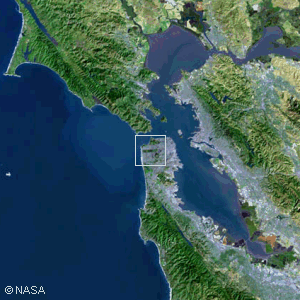
The San Francisco Bay AreaAlthough no single man-made structure is visible from this altitude (200 km or 120 miles), we can begin to see the larger works of mankind. This superb satellite photo includes portions of each of the nine Bay Area Counties; the major cities of San Jose, San Francisco, and Oakland; and dozens of smaller cities. Silicon Valley is the area in the lower right corner that includes Sunnyvale, Cupertino, Palo Alto, Santa Clara, San Jose, Fremont, and Milpitas. The San Andreas Fault runs from the upper left corner through the ocean just west of San Francisco and down through the peninsula communities to the lower right. When we started our downward journey, we were viewing huge volumes of space. The volumes displayed at each successive scale were reduced by a factor of one thousand. When we finally reached the Earth, we began viewing the projection of a spherical surface onto a flat image. This is the first image that is essentially flat. In the next several images we will be presenting areas, rather than volumes, of space. Copyright © 2016 by Bruce Bryson |
||||||||||||||