Scale: 104 meters = 10 km = 10 kilometers
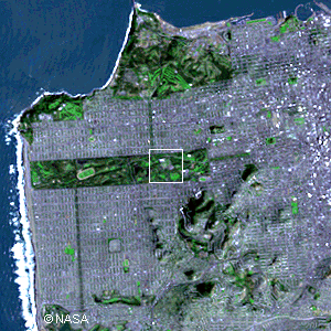
San FranciscoThis satellite picture shows most of San Francisco. At the top of the
picture is the Presidio with Fort Point at the tip. Fort Point is at
the base of the south end of the Golden Gate Bridge. Just to the right
of the Presidio is the Marina, an area that suffered significant damage
in the 1989 earthquake. The upper right of the image includes the downtown
and business sections of the City, continuing off the picture to the
right. On the left side is Ocean Beach and the Cliff House. The green
strip in the center is Golden Gate Park. The Haight-Ashbury is just
to the right of the park. Copyright © 2016 by Bruce Bryson |
||||||||||||||